The territorial disputes in the South China Sea form one of the most contentious issues in international relations. The disputes involve complex and overlapping claims from seven parties around the maritime area: the mainland China (the People’s Republic of China, PRC), Vietnam, the Philippines, Malaysia, Indonesia, Brunei, and Taiwan (the Republic of China, ROC). The area is usually considered to consist of four main components: the Paracels, the Spratlys, the Pratas and the Scarborough Shoal. However, a key sticking point related to the dispute is China’s U-shaped Line (see Figure 1). So far, China has not provided an answer to the exact meaning of the Line which will have implications to future resolutions. Such vagueness has led to much international confusion and apprehension over the nature of China’s claim.
Chung (2016) asserts that “the PRC’s official ambiguity over the line’s meaning plays a significant role in perpetuating the dispute. No meaningful resolution can emerge if it is unclear what the PRC claims in the first place”. Miyoshi (2012) presents the challenge it poses to the international lawyers as it raises the question whether “it is possible or permissible at all to claim a sea area encircled by a series of dotted or broken lines instead of an unbroken line”. Moreover, some scholars believe that China’s vague position may threaten the credibility of the United Nations Convention for the Law of the Sea (UNCLOS) at the regional level. For instance, Supriyanto (2016) argues that China’s insistence on the U-shaped Line “devalues Indonesia’s belief in the sanctity of UNCLOS”. According to Supriyanto, Indonesia found the Line problematic because it “clearly lacks international legal basis”. Therefore, the international community has been particularly interested in seeing a full clarification from China. If China is to hold fruitful negotiations with surrounding countries, it is essential that the meaning of the Line be thoroughly clarified.
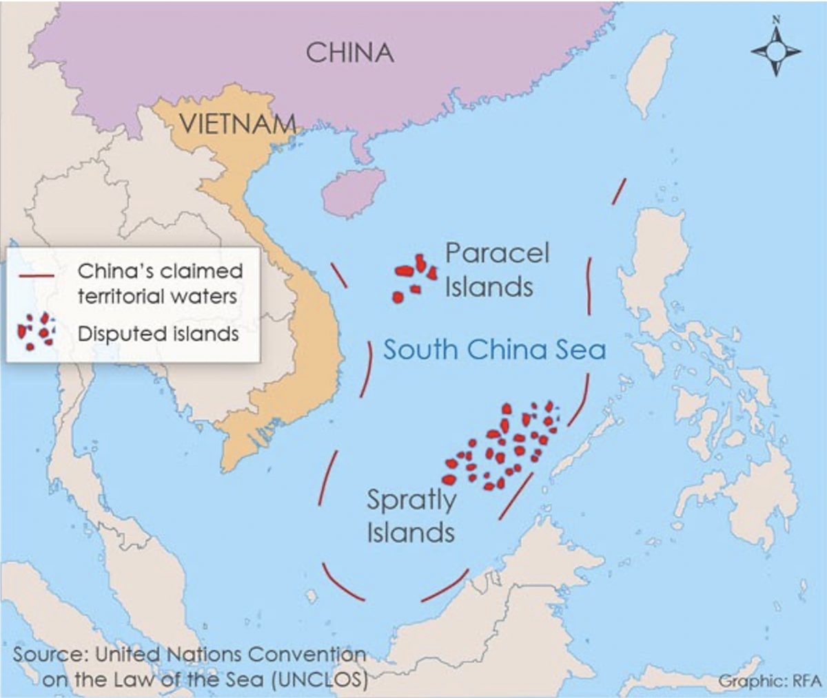
Figure 1: China’s U-shaped Line refers to the red segmented lines in the map (Ponnudurai, 2014).
But China faces a dilemma when it comes to the accurate definition and the cause of it is at least partly related to the ROC on Taiwan. Until now, few scholars have recognized this point in the literature of the English language. Some scholars in the academia may have documented the ROC’s historical activities in the South China Sea but they did not analyse their ramifications on today’s international negotiations. Therefore, this article argues that the Taiwan factor has added to the challenge to China’s definition of the U-shaped Line and to the bargaining process among relevant states.
To understand the Taiwan factor in the clarification of the U-shaped Line, it is necessary to take a look at the historical linkage between the ROC and the Chinese claim to the South China Sea. Basically, the ROC, which was founded in 1912 after the fall of the Qing Dynasty, is the creator of the U-shaped Line and made important efforts to assert its claim to the South China Sea. At that time the ROC regime ruled the majority part of the mainland China. These activities are deeply linked to the foundation of today’s Chinese claim.
As early as 1928, the Guangdong Provincial Government of the ROC sent a group of experts to the Paracels to investigate its geography. In the same year, the ROC government acquired the first map of the Paracels after the investigators accomplished the mission. This could be seen as an initial attempt of the ROC to administer the South China Sea (Chen, 2016). In the early 1930s, there was disagreement between the ROC and France regarding the sovereignty of the Paracels and the Spratlys. France based the claim on its colonial rule of Vietnam. But the ROC government protested against the French claim and quoted the 1887 Sino-French Convention on the boundary line between China and Vietnam. Its meaning was that the Paracels and the Spratlys were east to the French territory stipulated by the treaty. Despite this, France announced the occupation of 9 islands in the Spratlys in July 1933, which triggered ROC’s protest later (Chang, 1991). Also in response to the French claims, in June 1933 the ROC Interior Ministry established the Committee for the Review of Water and Land Maps, which was responsible for investigating the ROC’s territory. The Committee settled the names (in Chinese and English) of islands in the South China Sea and divided the South China Sea into four parts (Paracels, Pratas, Spratlys and the Macclesfield Bank) in December 1934. In April 1935, the Committee published a map of the South China Sea but this version did not include the U-shaped Line (Chen, 2016).
During the Second World War, the ROC government did not have much energy to deal with the South China Sea, but its activities in the region resumed shortly after the War. In October and November 1946, a Chinese naval squadron visited these islands and assisted in setting up radio and meteorological stations (Shen, 2002). In 1947, the ROC government released the “Map of the Location of the South China Sea Islands”, which was the first official map to include the Paracels, Prats, Spratlys and the Macclesfield Bank encircled by the U-shaped Line, consisting of 11 dashes. In the following year, the ROC dispatched warships to the archipelago to conduct surveys and erect landmarks (Wang, 2010). After 1949, the ROC government retreated to Taiwan as it lost the war with the Chinese Communist Party (CCP). But it does not mean that its activities related to the South China Sea stopped. For instance, in 1956 the ROC government sent a naval contingent to the Spratlys after the Philippine named Tomas Cloma claimed the discovery and occupation of the “Freedomland”. In April 1993, the ROC Executive Yuan approved the Guidelines for the Policy on the South China Sea in which it re-asserted its claim on the South China Sea and more than any other, used the strongest term “historic waters” to refer to the sea area (Wang, 2010). In 2005, the ROC suspended the guideline and it could be interpreted that Taiwan discontinued its claims to the “historic waters”. However, the U-shaped Line continues to survive on Taiwan’s official map of the South China Sea (Tsai, 2016). Thus, its current meaning remains vague.
The PRC inherited the U-shaped Line from the ROC after the PRC took power in the mainland since 1949. In August 1951, PRC Premier Zhou Enlai made a statement in response to the upcoming San Francisco Treaty, the treaty to formally end the Second World War between Japan and the Allies. Zhou (1951) announced that: “Although they were once occupied when the Japanese imperialists launched a war of aggression, they were all received by the Chinese government (the ROC’s) after Japan surrendered. The Central People’s Government of the People’s Republic of China hereby declares: The inviolable sovereignty of the People’s Republic of China in the Spratly Island and the Paracel Islands will not be affected in any way, regardless of whether or not the United States and Britain have provisions on the draft of Japan Peace Treaty.” Zhou’s statement was seen as “the PRC’s first international pronouncement regarding her claims in the South China Sea”. Although the PRC made no physical moves in the region until the 1970s, it formed an important legal basis of today’s Chinese claim (Granados, 2006).
The trouble for the CCP is that, any difference between the mainland and Taiwan in the interpretation of the Line will potentially cause problems. In the legal sense, if the defined nature of the Line from Beijing is different from Taipei’s, the international audience will inevitably ask why and possibly challenge the legitimacy of the Line based on such difference. Also, Wang (2015) has noticed that while the foreign audience have found the U-shaped Line unacceptable, there is a group of domestic audience in China that regards China’s assertion insufficient to protect its interests. To be specific, if the PRC’s final definition is widely regarded by the domestic audience as weaker than the ROC’s version, the CCP’s ability to defend the national sovereignty will be called into question. However, if the CCP adopts a very harsh approach, it may find the goal too ambitious to deliver, which still may cause both domestic and international challenges. The international audience may find it too aggressive while the domestic one may think it is unable to honour its promises.
On the contrary, if Taiwan dumps the Line altogether, the CCP may feel stabbed in the back because the ROC is the creator and joint owner of this Line. Realistically, Taiwan has no physical power or true inclination to occupy all the islands within the U-shaped Line. It also does not want to damage its relationship with the Southeast Asia. If Taiwan does give it up, the credibility of the Line will be inevitably impaired. So, the CCP actually hopes that Taiwan can maintain a degree of strength on it. A senior expert from China’s National Institute of the South China Sea Studies (NISCSS) expressed “three red lines” to the Tsai Ing-wen administration in 2016, which shows that the think-tank community in China was really paying attention to this risk (Zang, 2016). Among the three red lines, the first one was: the Tsai government must not declare the abandonment of the U-shaped Line. It was thought that due to outside pressure, Tsai had the possibility to compromise on this point. (The other two red lines were: the Tsai government must insist the Taiping Island as an island, not a rock; and that the Taiping Island must not be open to other countries for military use.)
To be sure, there are Taiwanese scholars who have also realized this problem and they are willing to discuss the issue with their mainland counterparts. Wang Kuan-hsiung (2019), Professor at National Taiwan Normal University, talked about his hope regarding the cross-strait academic exchanges: “We hope that in academic research, the understanding of certain things between the two sides of the Taiwan strait can be more consistent. If I can write something that becomes a consensus, I will be very proud of it.” Since 2002, scholars from the mainland China and Taiwan have been exchanging ideas in the annual Cross-strait Forum on the South China Sea hosted by the NISCSS, which is aimed to strengthen academic contacts and to promote South China Sea research cooperation. From 2010, there is also an annual Assessment Report on the Situation in the South China Sea, which is written by scholars from the mainland China and Taiwan. In the 2011 edition (Liu F.K. and Wu S.C., 2012), the need for coordination was explicitly expressed: “regarding the specific legal basis of the U-shaped Line and its legal meaning, both sides should find a consensus to further strive for the right to speak internationally on the issue of the South China Sea. Thus, what is urgent for the two sides of the strait is that they should conduct research and discussion on the collation of historical archives, so that the stance on the U-shaped Line can be the same and can form consensus. At the same time, an appropriate and reasonable statement should be generated according to the UNCLOS and particularly, on points where they may contradict.”
However, despite the hard work from scholars for years, the two sides of the Taiwan Strait have yet to reach an agreement on what the U-shaped Line actually means. Surely the root for such difficulty lies in the ambiguity of the Line itself. When the Line was first drawn in 1947, no definition was given then. Nowadays, various theories emerge from both sides of the strait. Some argue that the Line represents a “island attribution line” while others believe that it is the line of “historical rights”. Even without the factor of Taiwan, the mainland China may struggle to give a definite answer on its own. But the need for coordination between the mainland China and Taiwan certainly added to the difficulty, as has been mentioned above. During Ma Ying-jeou’s presidency in Taiwan, the two sides of the Taiwan Strait enjoyed a honeymoon period in which exchanges on economic, cultural and even political issues were smoothly carried out. But even during that time, no breakthrough was made. Part of the reason is that the governments on the two sides of the Taiwan Strait had political reservations. From the perspective of the mainland, allowing the Taiwanese authority to participate in the clarification of the U-shaped Line, which has significant international implications, would signal that Taiwan is a separate entity from the authority in Beijing, something that would violate the “One China” principle that the CCP gives everything to defend. From the Taiwan’s point of view, siding with the Beijing authority on the issue of the South China Sea would pose a threat to its relationship with the Southeast Asia and potentially hurt its friendship with the United States, something that it cannot afford to do. Given the situation that the Tsai administration is far more hostile to the mainland than the previous Ma administration, the likelihood of jointly coordinating the meaning of the U-shaped Line is even less. Thus, even if the academic community can reach a relatively consistent understanding about the Line, which is not achieved yet, raising it to the governmental level will be much harder.
To conclude, the ROC currently located in Taiwan is a player in the dispute of the South China Sea. One of its fundamental links to the dispute is that it is the creator and joint owner of the controversial U-shaped Line, whose meaning has not been thoroughly clarified yet. A dilemma for Beijing is that any difference in the definition of the Line will potentially cause trouble and thus it has the incentive to coordinate with Taiwan on this issue. But at the same time, the ambiguity of the issue itself and the political reservations at the governmental level may constrain the efforts by the academic community from both sides to reach a consistent interpretation of the Line. Thus, in the near future, such difficulty is likely to persist and the Taiwan factor will continue to be a barrier to China’s full clarification of the U-shaped Line. What it means to the international negotiation regarding the South China Sea is that China may still keep a degree of vagueness to the U-shaped Line for quite some time. And without full clarification, the best that can be hoped for is the de-escalation of the tension in the region, not a one-off resolution. In this sense, the Taiwan factor added to the prospect of a prolonged bargaining process among the claimants.
References
Chang, T.K., 1991. China’s claim of sovereignty over Spratly and Paracel Islands: A historical and legal perspective. Case W. Res. J. Int’l L., 23, p.399.
Chen, H.Y., 2016. zhong hua min guo zheng fu hui zhi nan hai zhu dao fan wei xian zhi jue ce guo cheng ji qi yi. guo shi guan guan kan 47, pp.91-118
Chung, C.P., 2016. Drawing the U-shaped line: China’s claim in the South China Sea, 1946–1974. Modern China, 42(1), pp.38-72.
Granados, U., 2006. Chinese Ocean Policies Towards the South China Sea in a Transitional Period, 1946—1952. China Review, pp.153-181.
Liu F.K., and Wu S.C., 2012. guan yu liang an nan hai he zuo de zheng ce jian yi. In Liu Fu-kuo and Wu Shicun ed. 2011 nian nan hai di qu xing shi ping gu bao gao.MOSS and NISCSS.
Miyoshi, M., 2012. China’s “U-Shaped Line” Claim in the South China Sea: Any Validity Under International Law?. Ocean Development & International Law, 43(1), pp.1-17.
Ponnudurai, P., 2014. US Draws Own Line Over South China Sea Dispute. Radio Free Asia. Available at: https://www.rfa.org/english/commentaries/east-asia-beat/claim-02092014205453.html [14/1/2021]
Shen, J., 2002. China’s sovereignty over the South China Sea Islands: A historical perspective. Chinese J. Int’l L., 1, p.94.
Supriyanto, R.A., 2016. Out of Its Comfort Zone. Asia Policy, (21), pp.21-28.
Tsai, C.T., 2016. Has Taiwan Implicitly Clarified the Meaning of the U-shaped Line?. Asia Maritime Transparency Initiative, CSIS. Available at: https://amti.csis.org/taiwan-implicitly-clarified-u-shaped-line/ [25 Dec 2020]
Wang, K.H., 2010. The ROC’s maritime claims and practices with special reference to the South China Sea. Ocean Development & International Law, 41(3), pp.237-252.
Wang, K.H., 2019. My interview with Wang in Taipei in 2019.
Wang, Z., 2015. Chinese Discourse on the “Nine-Dashed Line” Rights, Interests, and Nationalism. Asian Survey, 55(3), pp.502-524.
Zang,H., 2016. da lu zhuan jia da zhong ping :min jin dang hui zai nan hai tui que ma ?. CRNTT. Available at: http://hk.crntt.com/doc/1044/8/3/4/104483406.html?coluid=93&kindid=15730&docid=104483406&mdate=1126002020 [25 Dec 2020 ]
Zhou,E.L., 1951. zhou en lai wai zhang guan yu mei ying dui ri he yue cao an ji jiu jin shan hui yi de sheng ming. Ren min Wang. Available at: http://world.people.com.cn/n1/2016/0627/c1002-28481582.html [25 Dec 2020].
Further Reading on E-International Relations
- Is China Under-Exploiting One Legal Avenue in the South China Sea?
- Opinion – Why Tsai Ing-wen’s Victory is a Blessing for the Taiwan Strait
- Opinion – Omens for US-Taiwan Relations in the Biden Administration
- Opinion – Taiwan Could Be to China What Canada Is to the US
- Opinion – Taiwan’s Almighty Squeeze
- How Long Will the Dragon Wait? China and the Retrocession of Taiwan